

Spars, Sails and Rigging
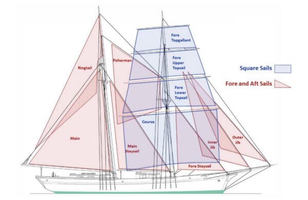
Look up! See the MT standing rigging. As you stand here on the dock, try to trace some lines with your eyes. You will see two masts, the foremast and the mainmast. Each mast is stabilized by standing rigging called stays and shrouds. The standing rigging is not adjusted while under sail, but functions to distribute load across the deck, as there is considerable load on the masts when under sail.
The sails are set, struck and controlled by a collection of lines called ‘running rigging’, which is adjusted throughout the sail to angle the sails most appropriately to the wind. This process is the active part of sailing.
The Matthew Turner has fore-and-aft triangular sails, as well as square sails. This combination of sail types created a ship that was the fastest and most efficient of its time. The square sails give the ship power sailing downwind, whereas the triangular sails are more efficient sailing at a sharp angle up into the wind.
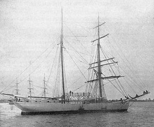
The Galilee
The Matthew Turner is a 132 foot long ship designed after the Galilee, which was built in the late 1800s by the ship builder and designer Matthew Turner.
Launched in 1891, the Galilee was known as the “Queen of the Pacific” for almost 40 years. She sailed from San Francisco to Papeete, Tahiti between 1891 – 1896, and was admired as an especially sleek, fast ship. The Galilee set the record for the SF-Tahiti passage on her maiden voyage, clocking 19 days from SF -Tahiti and 22 ½ days on her return passage, where it typically took 35 days to make the journey. This record has never been broken by another wooden sailing ship.
In 1905, the Galilee was selected to conduct the Carnegie Institution’s Oceanic Magnetic Survey of the Pacific Ocean, as a metal-hulled vessel would interfere with scientists ability to determine the deviation caused by the Earth’s magnetic field. The Galilee completed three expeditions on the Pacific, then was sold in 1911 and re-rigged as a three-masted fishing schooner.
Beached in Sausalito in 1933, at what is now known as “Galilee harbor” she was central to the bohemian artist live-aboard movement that developed in the wake of the Great Quake of 1906. Her transom was removed and brought to Fort Mason, where it remains on display to this day.
Matthew Turner – Shipbuilder (1825 – 1909)
Born in Geneva, Ohio in 1825, Matthew Turner travelled to California to pursue prospecting during the Gold Rush. His efforts proved worthwhile, and he was successful enough in his endeavors to purchase a schooner, the Toronto, with his gold fortune. Industrious and ambitious, Turner employed his schooner in the lucrative lumber industry, shipping timber down to San Francisco from the Mendocino Coast to supply the rapidly growing city. After upgrading his ship several times, he established a successful trading company which brought goods to California from Tahiti.
The first ship Turner designed was the Nautilus in 1868, having found existing ship designs too slow for his preference. The Nautilus proved to be so fast and efficient that Turner launched into the shipbuilding trade in the 1870’s, establishing a base near Hunter’s Point. This shipyard eventually expanded to Benicia in 1882, where Turner oversaw the construction of practical and efficient ships that would transform the industry standard.
Matthew Turner designed and built more sailing vessels than any other American shipbuilder. He launched 228 ships in a period of 33 years, 154 of which were built at his Benicia shipyard.

Shipping & Trade: Brigantines in the Late 19th Century
The brigantine is a model of sailing ship developed in the 17th century as a faster and more efficient evolution from the galleon and caravel, which were used by Europeans to explore and chart the first maps of the California coastline during the Age of Exploration.
Trade Items
In the 19th century, it was a common route for ships to sail from the East coast of North America to California via Cape Horn, often carrying an assortment of manufactured goods and household items to exchange or sell. These ships would then fill their hold with cattle hides, tallow and sea otter pelts to be brought back to the East Coast.
In this era, before the Transcontinental Railroad or contemporary road systems were established, ships were the primary means of travel and transport for trade-goods across oceans, and remained predominant until steam ships began to replace sail in the early 1900’s.
Indigenous History of California
We acknowledge that the Indigenous people of North America have populated this land for over 10,000 years. In the San Francisco Bay Area, the Coast Miwok lived north of the Golden Gate in present-day Marin and Sonoma Counties, while the Ohlone (Costanoan) peoples lived along the San Francisco Peninsula and south toward Monterey. They lived in close relationship with the natural world, sustainably managing the land through hunting, gathering, and traditional ecological practices long before European colonization.
Spain began colonizing Mexico in the 16th century, but did not discover the San Francisco Bay until the Portola expedition in 1769. The Spanish established the Mission San Francisco de Asis, or Mission Dolores in 1791, making it the oldest intact structure in the city, as well as the Presidio military post.
The Spanish Mission system sought to convert the Native peoples of California to Christianity and subjected them to widespread oppression of cultural traditions, forced labor, family separation, poor living conditions, and inadequate nutrition. By the 19th century, over 60% of the indigenous population had been killed by epidemics of European-bourne disease, including smallpox, syphilis, and diphtheria, to which they had no historical exposure or natural immunity. European-introduced livestock destroyed the native flora and brought invasive plant species, disrupting the Native people’s ability to independently subsist off of the land using their traditional practices.
Mexico subsequently gained independence from Spain in 1821, and the territory of California remained a part of Mexico until it was ceded in a vast swath of land in the Treaty of Guadalupe Hidalgo, which marked the end of the Spanish-American war in 1848.
California was quickly admitted as the 31st state in the union on September 9, 1850, but violence against Native peoples continued. Between 1846 and 1870, California’s Native American population declined from 150,000 to 30,000 people (Madley, American Genocide).
Alcatraz Island is a significant landmark in the history of the San Francisco Bay. Used as a penitentiary and a prison since the time of the Spaniards, many Native Americans were imprisoned here, including a group of 19 Moqui Hopi in 1895 for resisting the forced matriculation of their children into U.S. Boarding Schools. In 1969, a 19 month occupation of Alcatraz Island was organized and led by Richard Oakes, and a group of Native American college students and activists from the Bay Area. United under the banner of “Indians of All Tribes” this act of defiance was intended to bring Native American history, identity, and the fight for self-determination, tribal sovereignty and traditions to the attention of the American public. While the occupation ended with a forcible intervention from the US Government, it marked a turning point in the national dialogue surrounding Native American rights.
There are currently 109 federally recognized Native American tribes in California.
How were ships central to the development of San Francisco between 1849 – 1915?
During the California Gold Rush and the decades that followed, San Francisco’s harbor became the principal port on the West Coast, serving as the gateway for people, goods, and ideas that transformed a small settlement into a thriving commercial and industrial center. The city’s history is inextricably linked to wooden ships, the city’s waterfront, and the remarkable geological and ecological phenomenon that is the safe harbor of San Francisco Bay.
1849: The Gold Rush
1848: The discovery of gold at Sutter’s Mill ushered in a new era for California. The mania inspired by the gold rush caused the population of San Francisco to grow rapidly, transforming what had been the sleepy town of Yerba Buena into a booming city of 25,000 people in less than a year. People of all backgrounds from across the world immigrated to San Francisco, seeking economic opportunity and adventure.
The majority of gold seekers elected to buy passage on a ship and travel by sea to the port of San Francisco. In the late 1800’s it took between 4 – 8 months to complete the 15,000 mile voyage from the East Coast around Cape Horn to San Francisco (US Library of Congress). This was a long and dangerous journey undertaken by thousands of rugged, determined characters, many of whom lost their lives along the route.
Between April and December of 1849, 549 ships sailed through the Golden Gate to arrive in San Francisco, their crews largely deserting to pursue the dream of striking it rich. By 1851, over 800 abandoned ships littered the shoreline of San Francisco (NPS). Many of these ships were repurposed and converted into warehouses, restaurants, saloons and storefronts, while many more burned down or deteriorated slowly in the muddy flats at the city’s shoreline.
The shoreline of Yerba Buena cove has evolved significantly in the nearly 200 years since the city’s founding. Despite enduring devastating fires throughout its early history and the catastrophic 1906 earthquake, San Francisco’s identity remains firmly anchored to the ships that carried the fortune seekers, entrepreneurs, and opportunists to the shores of Yerba Buena Cove. Those vessels brought more than people and cargo—they carried a spirit of resilience, grit and determination that was the impetus of the city and continues to define San Francisco to this day.
Construction of the MT
As you pass below the decks of the ship, you will see evidence of the incredible craftsmanship and attention to detail. Stop in the midhold at the card table, and observe the main mast stem. Look up at the Douglas fir planks for the underdecking.
The Matthew Turner is the first wooden tall ship built in the Bay Area in almost 100 years, and is a testament to the nautical legacy of the region and to the power of a community to steadfastly pursue their collective vision. From 2012 to 2020, she was built by the hands of over 600 volunteers who dedicated over 100,000 hours to the Matthew Turner’s construction, and who continue to maintain the ship as she sails regularly upon the SF Bay.
Remember earlier, when I mentioned that the Galilee was chartered for the Carnegie survey of Earth’s magnetic field in the early 1900’s? Well, it turns out that was important. In recognition of the ship’s importance in the study, the Smithsonian outlined the hull of the Galilee, and these records would be the only remaining diagrams of a Turner ship, all of his other designs tragically having been lost in a fire.
These rudimentary Galilee plans were sent to Tri-Coastal Marine, a Bay Area naval architecture studio, where they were modified and slightly modernized, resulting in a ship that was as long as the Galilee, but slimmer and lighter, displacing 175 tons as opposed to the Galilee’s 328.
Construction of the Matthew Turner in Sausalito
A local businessman allowed Call of the Sea to erect a circus-type tent in a field near to the Sausalito waterfront along Marinship Way, which is a historic WW2 shipyard which produced 93 ships between 1942-1945. It was in this venue that a small crew of hired professional shipbuilders, led by master shipwright Franz Baichl, directed over 600 volunteers in the many steps of wooden ship building.
The Matthew Turner is built of epoxy-laminated Douglas-fir which was sustainably grown on the Mendocino Coast, and was donated by the Conservation Fund, a nonprofit who work to promote environmental preservation and sustainable economic development.
The major stages of the construction of Matthew Turner included:
- First, casting of the lead keels, which provide a heavy ballast to lower the center of gravity and give the ship stability
- Harvesting, milling and planing the donated logs into slabs and planks
- Laminating or gluing together the planks to create the frames and major structural elements, i.e. the “bones” of the ship.
- Planking the ship – or adding the horizontal planks perpendicular to the “ribs” of the ship.
The hull of the Matthew Turner was launched in 2017, but it wasn’t until 2020 that the masts, spars and rigging were raised, and the vessel was awarded US Coast Guard approval.
A Sailor’s Life
What you see in the midhold of the MT is very different from how a brigantine cargo ship would have looked in the late 18th century. The midhold of a brigantine was designed to be spacious to hold cargo, goods which were to be transported and traded along the ship’s journey. The Galilee sailed in Matthew Turner’s Tahiti Packet Line, which carried passengers and lighter items such as mail and perishable fruits across the Pacific.
Life of a Sailor: 19th Century
Sailors in the 19th century lived aboard without contact with land for months at a time, coming into port at various locations along the route for fresh water and provisions, or strategically to collect a trade item. The operational hierarchy of a ship was paramount to the voyage’s success: the Captain ranked as the highest officer, whose authority was not to be questioned, and was supported by his first and second mate.
The day-in-the-life of a sailor would have involved breaking into duty watches, where the crew would split up responsibility for sailing and maintenance of the ship, where some would work and some would have time to rest. Generally, all hands would be called to raise, strike or significantly alter the sail plan in the event of an inclement weather event, or when coming in to harbor.
To maintain tradition, the crew of the Matthew Turner still sleep in the forecastle, the foremost compartment in the ship, which is what you passed by as you came down the stairs from the galley. However, our crew enjoys a drastically improved standard of living compared to sailors of the 18th century. Where their forebearers would have eaten hard-tack & salt beef, our crew enjoys a diverse and nutritious diet and a benevolent captain and first mate.
Navigation in the Age of Sail
Before the advent of modern technology, sailors looked to the sun, moon, stars to find their way. Sailors employed specialized navigational instruments, mathematics and engineering to determine their position and bearing, and relied on nautical charts to increase the reliability and accuracy of these readings.
One of the earliest navigational instruments, the cross staff was used to measure the altitude of the Sun above the horizon. Once having determined the angle of the celestial object above the horizon, the navigator was then able to use charts and maps to determine their latitude. A major flaw of the cross staff design is that to take a reading, the navigator is required to look directly at the sun. Over time, this would cause major eye damage and may be why so many pirates wore eye patches.
Invented in China in the 12th century, early magnetic compasses consisted of a piece of lodestone, which is a naturally occurring magnetic ore, floating on a stick or cork in a bowl of water. The magnetized material would align with the Earth’s magnetic field, while early navigators observed that the stick aligned with the North Star. This rudimentary design was soon improved to the style of magnetic compass we are familiar with today, where the compass needle is mounted on a pin and spins in the center of the compass bowl to indicate north and south. Using a compass, navigators determine their bearing, which indicates the orientation of the user to a reference point, usually magnetic north (360˚/0˚).
To determine their speed, sailors used a knot meter, and later the taffrail log. The knot meter consisted of a wooden bar tied to a rope with evenly spaced knots tied into it. The wooden component was tossed into the water from the stern of the ship, and the rope paid out, the amount of knots, which is a unit of speed equal to one nautical mile per hour (1.15 statute miles), counted over a period of time were used to calculate the ship’s speed. The Taffrail log is a more advanced iteration of the knot meter, which functions similar to a car’s odometer to measure the vessel’s distance travelled.
Basic Navigation, Explained
To determine location using local landmarks, such as when at anchor in a cove, sailors use a compass to take several bearings, from which they can triangulate their position. The intersection of the bearings is known as a fix. A vessel’s heading is the direction that she is pointed at any given moment. A vessel’s course is the intended direction of the vessel’s path.
Specially created for marine navigation, Nautical charts and maps provide detailed information on coastlines, water depth, local hazards, and other important features.
When at sea, out of sight of land, sailors also use a tactic called Dead Reckoning to estimate their position. Given the vessel’s compass heading, speed, and time spent at each heading and at each speed, the navigator can use their nautical charts to determine their approximate location, accuracy of which depends on the reliability of the charts and the sailor’s navigational prowess.
Conclusion
Perhaps the great era of tall ships came to a close at the end of the 19th century with several monumental transportation and technological advancements. The advent of steam-powered ships in the early 20th century, such as the Titanic, began to gradually phase out sail-power. The First Transcontinental Railroad was completed in 1869, connecting California overland to New York and the rest of the county. And in 1914: the completion of the Panama Canal, which created a new route to connect the Atlantic and Pacific Oceans, shortening the travel distance from the East Coast by thousands of miles, and signified that travellers and traders no longer had to navigate the infamously dangerous Cape Horn, at the southern tip of South America.
The high seas were still the venue for shipping traffic and trade, but tall sailing ships were no longer the king of the sea, and perhaps never would be again. However, our dedication to understanding the complexities of our city’s history and our Californian heritage, and our appreciation for tall ships prevails.
The Matthew Turner sails regularly throughout San Francisco Bay and the surrounding coastline. Some 6,000 young people participate in our programs each year, and more than 50% come from under-resourced communities who are supported by scholarships.